Land Cover & AgricultureSwitch To Agriculture PortalSwitch To Land Cover PortalTracking urban expansion and gathering crop statistics on country wide basis, using Satellite Remote Sensing (SRS) and Geographic Information System (GIS) Land Cover & AgricultureSwitch To Agriculture PortalSwitch To Land Cover PortalTracking urban expansion and gathering crop statistics on country wide basis, using Satellite Remote Sensing (SRS) and Geographic Information System (GIS) Land Cover & AgricultureSwitch To Agriculture PortalSwitch To Land Cover PortalTracking urban expansion and gathering crop statistics on country wide basis, using Satellite Remote Sensing (SRS) and Geographic Information System (GIS)
Land Covers describes the natural and human-made features on the landscape, such as forests, croplands, water bodies, settlements, and grasslands, while agriculture examines the cultivation of crops, soil conditions, and farm productivity. Agriculture remains the backbone of the economy, employing a large share of the population and sustaining national food security. Rapid land use change, population growth, climate variability, and unsustainable farming practices are putting pressure on croplands, rangelands, and natural habitats. Shifts in rainfall, extreme temperatures, soil degradation, and water shortages are already affecting productivity and rural livelihoods.
To respond to these challenges, SUPARCO uses satellite-based land cover mapping and agricultural monitoring to assess changes across the country with consistent and repeatable observations. Using multispectral imagery, vegetation indices, seasonal time-series analysis, and modern geospatial technologies; including GIS, remote sensing, and machine learning; SUPARCO provides clear insights into crop health, land degradation, cropping patterns, and expansion or loss of key land cover classes. This information helps guide evidence-based planning, improve resource management, and support climate-smart agriculture.
SUPARCO’s work helps to strengthens Pakistan’s food security, support better water and land resource management, and help researchers, policy makers and farmers for environmental conservation, agricultural improvement, and long-term land management, ultimately contributing to sustainable development and improved livelihoods.
Keypoints
Key Capabilities & Monitoring Parameters
— National Land Cover Mapping & Change Detection
Tracking long-term shifts in forests, croplands, rangelands, built-up areas, and wetlands to support planning and environmental management.
— Crop Type Identification & Crop Mapping
Using multi-temporal satellite data to classify major crops such as wheat, rice, cotton, sugarcane, and maize for each growing season.
— Crop Health Monitoring
Detecting crop health using vegetation indices and early indicators of drought stress, pest attacks, nutrient deficiency, or waterlogging.
— Yield Estimation & Production Forecasting
Predicting crop yields through satellite-based vegetation trends and agro-meteorological models to support market and food security planning.
— Land Degradation & Desertification Assessment
Mapping areas affected by soil erosion, salinity, overgrazing, and declining vegetation cover, particularly in arid and semi-arid regions.
— Flood Impact Assessment on Agriculture
Evaluating crop damage and submerged farmland after floods using multispectral and synthetic aperture radar (SAR) imagery.
Recent Studies
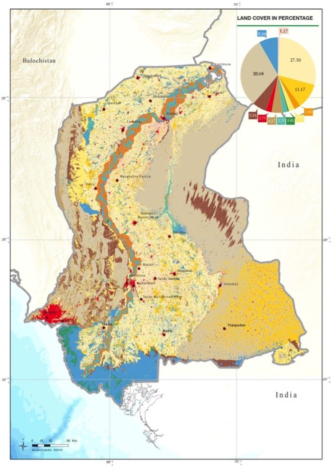
SINDH
Land Cover in Percentage
×
Images
04
Image Gallery
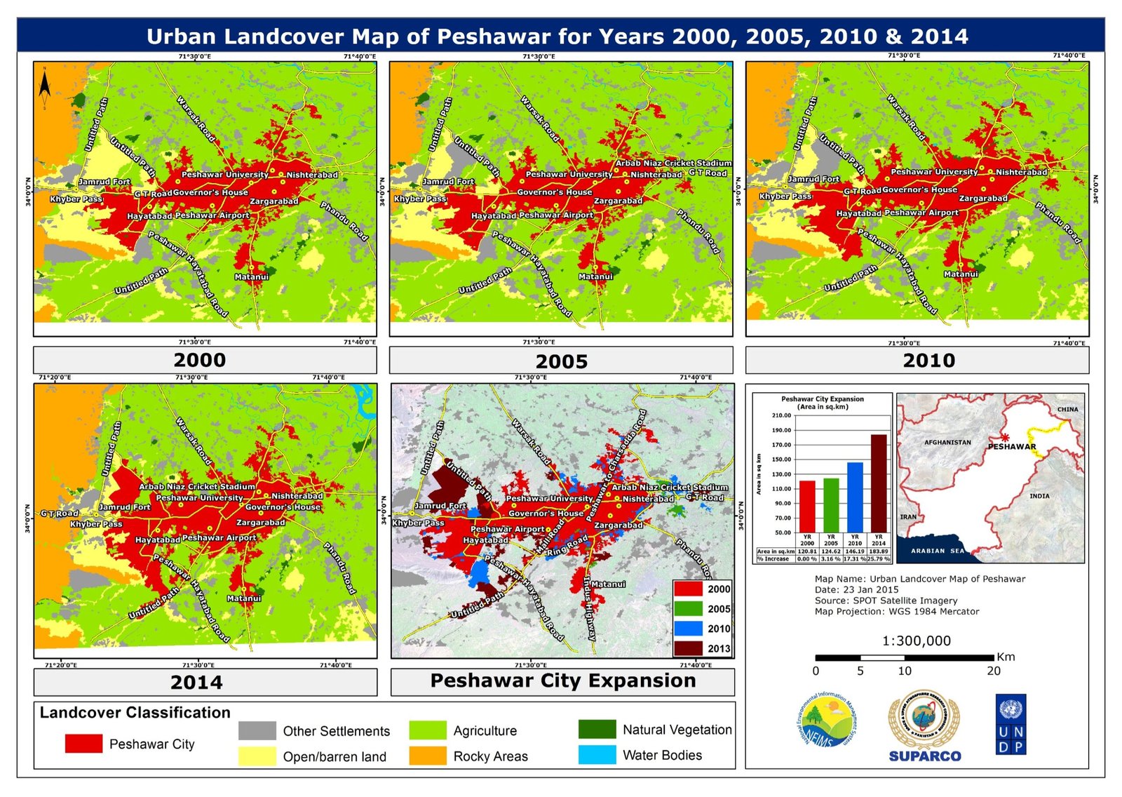
Urban Landcover Peshawar, Years 2000, 2005, 2010,2014
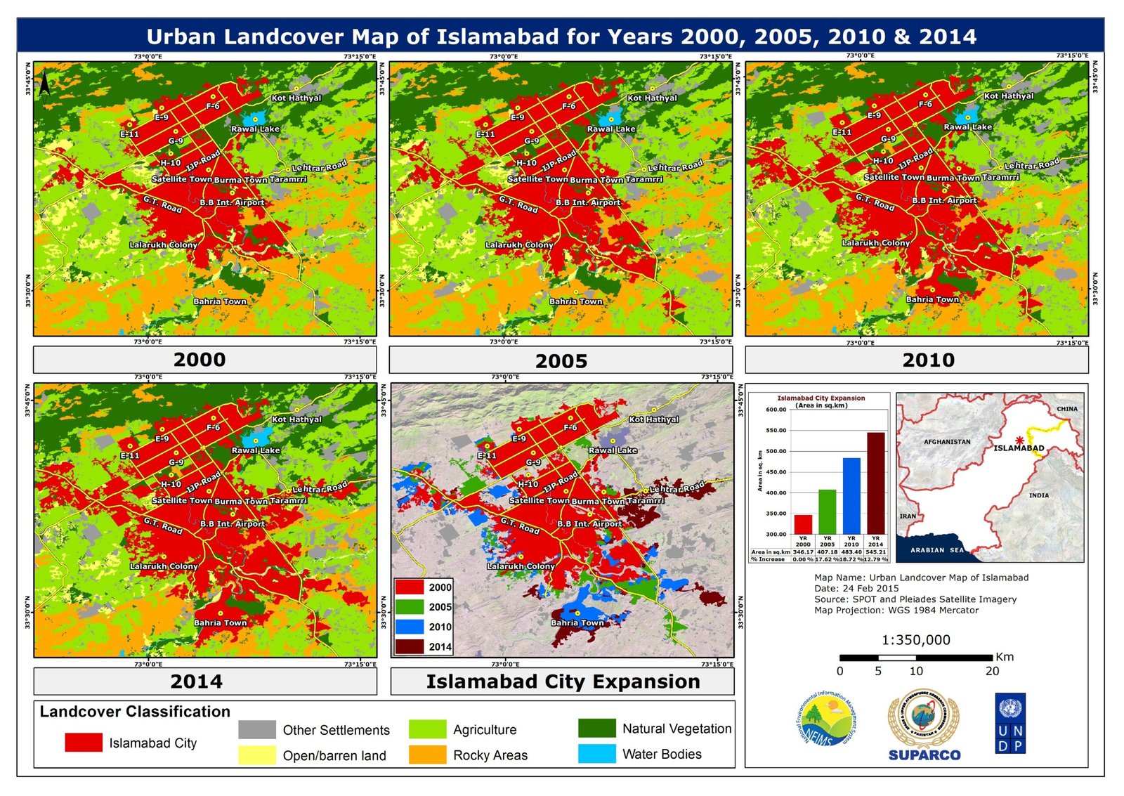
Urban Landcover Islamabad, Years 2000, 2005, 2010,2014
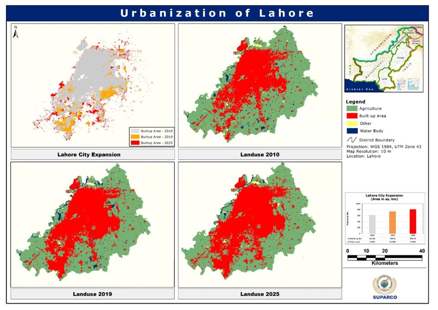
Urban Landcover Lahore, Year 2000, 2005, 2010,2014
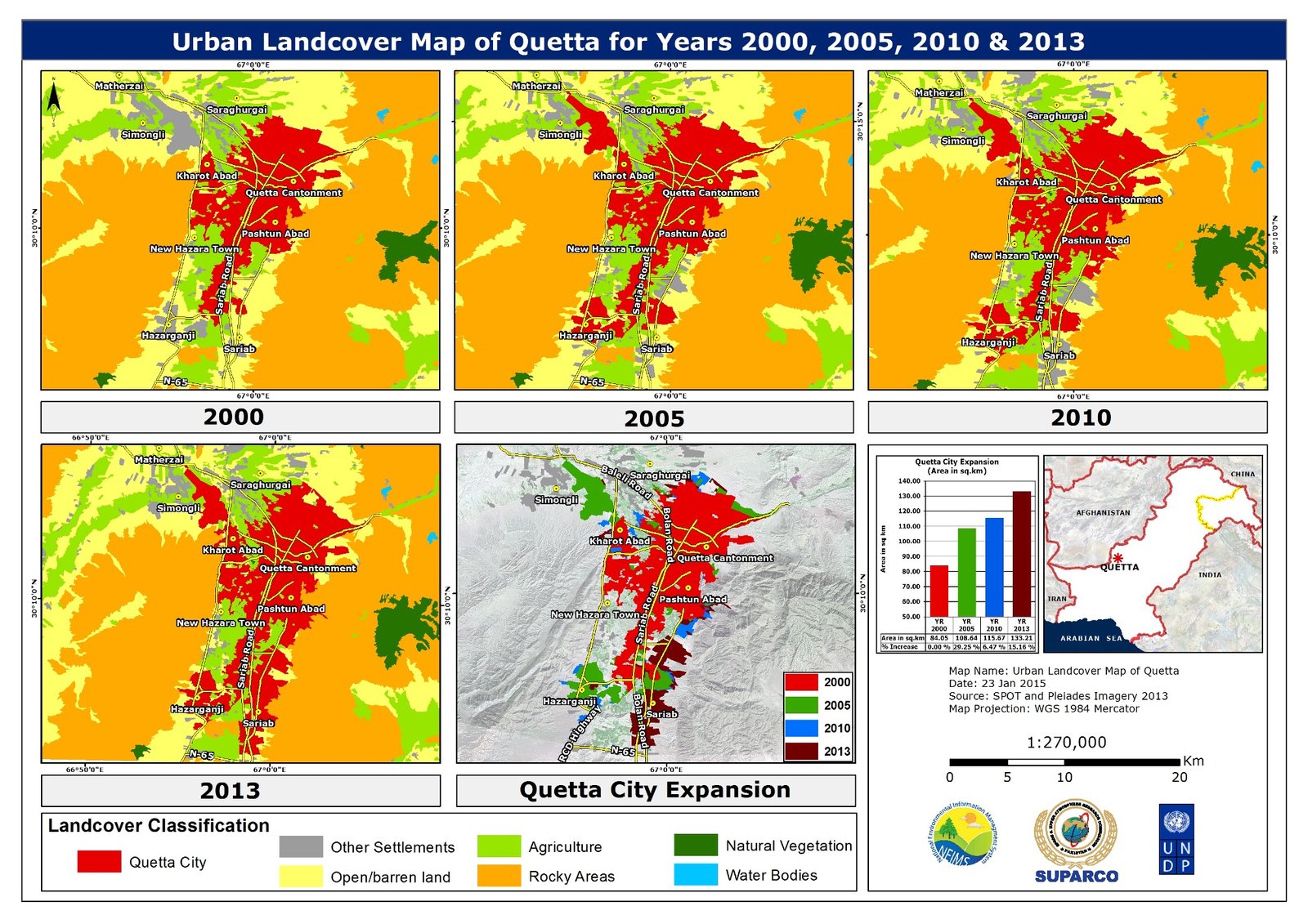
Urban Landcover Quetta, Year 2000, 2005, 2010,2013
Portal Information
Land Cover and Agriculture Geospatial Portal
SUPARCO uses multi-spectral satellite imagery and change detection techniques to monitor land cover and agricultural conditions across Pakistan. National land cover maps developed for 2010 and 2019 provide a consistent baseline to track changes in croplands, forests, rangelands, and built-up areas. Satellite-based vegetation indices are used to assess crop health, seasonal growth, and climate-related stress. The information supports evidence-based planning for food security, sustainable land management, and climate-resilient agriculture.
")
")

")
")