(2)")
And Encroachment
")
And Encroachment
")
And Encroachment
(2)")
")
")
- Suparco Home
- Waterways & Encroachment
Rivers are naturally dynamic systems, they change their shape, shift their paths, and reshape their beds over time. Sometimes these changes happen slowly, taking decades, while at other times a major flood can alter a river’s course within days.
With climate change, weather-related disasters—especially floods—are becoming more frequent and more intense. According to the EM-DAT global disaster database, Pakistan has faced 89 flood events in the last 25 years, causing major damage to settlements, crops, infrastructure, and local economies. These impacts worsen when people build houses, roads, or agricultural fields inside active riverbeds and floodplains, leaving communities more exposed to danger.
To manage these risks, satellite-based monitoring has become one of the most powerful tools available. Satellites allow us to regularly and accurately observe rivers, drainage networks, floodplains, and areas where encroachment is taking place. This is especially important in Pakistan, where river systems are large, complex, and constantly changing.
SUPARCO, using its own Earth-observation satellites as well as free global satellite missions, can now provide continuous and reliable assessments of river behavior and surrounding land use. These satellite insights help government agencies and planners make informed decisions about river management, flood protection, encroachment control, and climate-resilient development.
Key Capabilities & Monitoring Parameters
— Tracking Waterways Over Time
Regular satellite-based mapping to see how rivers and streams change their paths and shape.
— Identifying Encroachment Hotspots
Detecting areas where houses, farms, or infrastructure have expanded into riverbeds or floodplains, using before-and-after satellite imagery to confirm cleared areas where encroachments have been removed.
— Monitoring River Dynamics
Observing long-term shifts in river channels, erosion, and sediment deposition.
— River Erosion and Deposition Modelling
Identifying areas where rivers are likely to erode land or deposit sediment.
— Probabilistic Flood Hazard Modelling
Creating flood-risk maps based on different flood scenarios to help define floodplains and safe zones.
Indus River dynamics along Larkana city concise
River encroachment evidences from different rivers brief
Evidence from Neelam River: Encroachment Along Tributary of Neelam River
Uncontrolled urban expansion along Tributary of Neelam River in the vicinity of Muzaffarabad city, AJK, has considerably increased the flood risk. Satellite images acquired in 2002 and 2023(source: google earth imagery) show how construction along the stream has narrowed the breathing space of the stream increasing the flood risk during extreme events. This man-made disaster, not just a natural one, highlights the urgent need for government policies to enforce no-build zones and relocate at-risk structures.
Evidence of Natural Stream Encroachment near Gilgit City
A comparison of the 2013 and 2023 satellite images clearly reveals the rapid and largely uncontrolled expansion of settlements along a natural stream near Gilgit City. This stream is fed by upstream glacial lakes within the catchment, making it highly sensitive to climate-induced hazards such as Glacial Lake Outburst Floods (GLOFs). Over the past decade, urban growth has progressively encroached into the natural flood conveyance zone and alluvial fan of the stream, significantly reducing its capacity to safely accommodate high-magnitude flows. Such land-use changes have altered the natural drainage patterns and increased the exposure of residential and commercial infrastructure to flood hazards.
In the event of a GLOF or extreme precipitation-driven flow, the confined channel and obstructed floodplain could result in sudden overbank flooding, debris flows, and widespread destruction. The scale of potential damage has been substantially amplified by human negligence, weak enforcement of land-use regulations, and the absence of risk-informed urban planning at the governmental level. Despite clear evidence of hazard-prone zones identifiable through satellite imagery and geomorphological indicators, construction activities have continued unchecked. This case highlights how climate change–induced hazards, when combined with unplanned urbanization, can transform natural processes into severe disasters, underscoring the urgent need for stricter regulatory frameworks, hazard zoning, and integration of geospatial analysis into urban development planning.
Evidence from River Swat: Uncontrolled expansion of Bahrain Town along the river
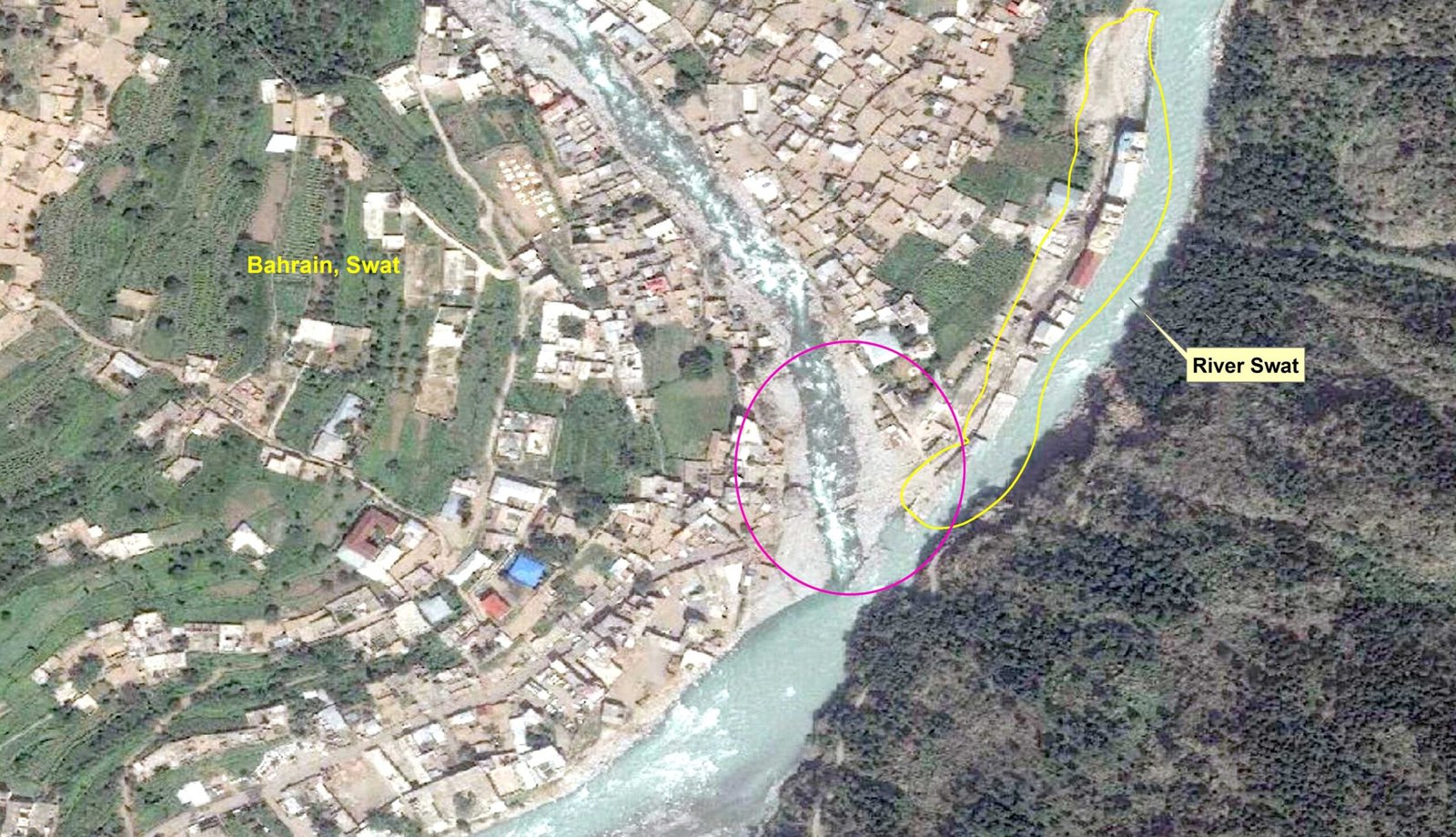
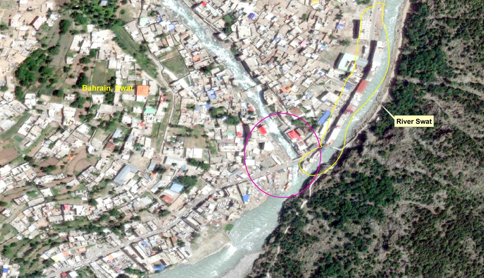
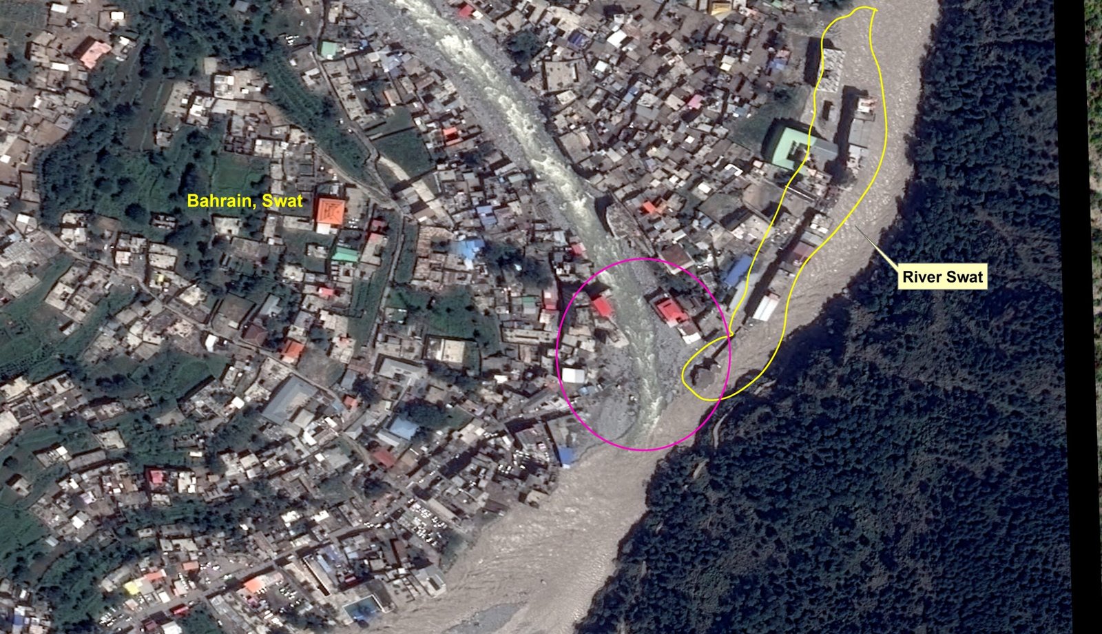
Unregulated urban expansion into the Swat River’s floodplain at Bahrain town has drastically increased flood risk. Satellite images from 2010-2022 show how construction in the riverbed narrowed the channel, directly causing the severe damage during the August 2022 floods. This man-made disaster, not just a natural one, highlights the urgent need for government policies to enforce no-build zones and relocate at-risk structures.
- Problem: Unchecked construction in the Swat River’s floodplain narrowed the channel and increased flood vulnerability at Bahrain town.
- Evidence: 2022 satellite imagery shows buildings in the former riverbed were destroyed, proving the link between encroachment and damage.
- Solution: Governments must enforce strict no-build zones based on science and relocate existing high-risk developments to prevent future disasters.
Satellite imagery proves that unchecked construction in the Swat River’s floodplain directly caused catastrophic 2022 flooding, demanding immediate government action to enforce no-build zones and prevent future development in high-risk areas.
Waterways Geospatial Portal
SUPARCO has earth observing satellite resources as well as the processing capacity of satellite images for various earth sciences applications. Temporal images are utilized to monitor long-term river course changes, encroachment extension along the river courses, flood event monitoring, and verification of removed encroachments reported by relevant provincial departments.